|
Issued: 0900hrs Saturday 23rd August 2026
Duty forecaster: Garry Nicholson
Warm and humid, then cooler into the Bank Holiday
A dry and fairly warm start to the new week, then a trend to more unsettled weather through midweek as low pressure develops from the south. This brings scope for some heavy rain and thunderstorms moving northwards in the second half of the week, a risk of sustained heavy rainfall for some places late this week. An unsettled theme continues into the extended weekend with bursts of rain around.
For the weather for the next few days click here
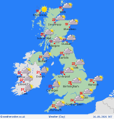 Wednesday 26/8/26 Wednesday 26/8/26
Low pressure south of Ireland on Wednesday. Fairly extensive high cloud and sporadic areas of rain moving north across England, Wales and Ireland. Odd heavier outbreaks of rain, but some places seeing often dry weather. Drier for much of Scotland, the best sunny spells in the west of Scotland. Some thundery rain by evening may reach the English Channel. East to southeasterly breezes, locally gusty. Highs at 17C in Scotland, 23 to 27C in England and Wales, feeling quite humid.
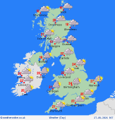 Thursday 27/8/26 Thursday 27/8/26
Low pressure toward the southwest developing into a more active system through Thursday. An area of rain sweeps northward across England, Wales and Ireland, reaching southern Scotland. Outbreaks of rain too in eastern Scotland. Drier in western and northern Scotland. Heavy showers follow in southern England with a risk of thunderstorms here especially later in the day. Breezy southeasterlies northern England and Scotland. Quite humid, highs at 19 to 25C for most.
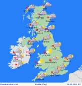 Friday 28/8/26 Friday 28/8/26
Low pressure circulates slowly over the country on Friday bringing rain to northern England and Scotland, risk of sustained heavy falls in places. Brighter southern England, Wales and Ireland but with a scattering of heavy showers here. Variable strong winds, mostly westerlies in the south. Cool in rain. Highs at 14 to 22C.
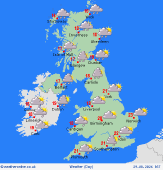 Saturday 29/8/26 Saturday 29/8/26
Low pressure drifts slowly north on Saturday. Areas of rain and showers, most frequent north and west, but some showers forming in southern areas too. Locally heavy at times and perhaps thundery too. Fresh west to northwesterly winds, strongest in the north. Highs at 15 to 22C.
Sunday 30/8/26
Low pressure to the northeast on Sunday. A mix of sunny spells and heavy showers, whilst some places escape with drier intervals. West to northwesterly breezes. Highs at 15 to 21C.
Monday 31/8/26
Cool and showery northwesterlies for Bank Holiday Monday, areas of heavier showers likely focused toward central and eastern England by afternoon. Highs 14 to 20C.
|


